|
Updated Information
|
Date |
Camp Site or Accommodations |
GPS |
Distance Today:
421km |
Meals
Salad, crackers with mussels |
Weather |
|
Addo Elephant Park, South Africa |
22 November, 2004 |
Park campground |
33°26.661’S x 25°44.701’E |
Odometer: 44981km |
Sunny & cool, 80(F)
degrees |
|
It was sunny and warm this
morning so after breakfast we grabbed wetsuits and surf boards and headed
for the beach. After a little surfing (or attempting to surf anyway) we
relaxed on the beach for awhile, then somewhat reluctantly packed up to
continue our journey south-west along the coast. We stopped for a picnic
lunch in East London (seems to us it should be South London) which seems
to be a pleasant town. We stopped again in Port Alfred to check our email,
then headed to Addo Elephant Park. We arrived too late for a game drive,
although we did see some elephant and buffalo from the campsite. |
|
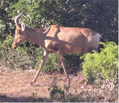
Hartebeest |
|
Updated Information
|
Date |
Camp Site or Accommodations |
GPS |
Distance Today:
295km |
Meals
Salmon Curry |
Weather |
|
Tsitsikama National Park, South Africa |
23 November, 2004 |
Park campground |
34°01.418’S x 23°53.408’E |
Odometer: 45213km |
Partly cloudy, 82(F) Degrees |
|
We awoke early for a game
drive and saw lots of hartebeest, warthog, and kudu, as well as elephant.
Interestingly, there were no Impala! After breakfast we left the park and
headed for Tsitsikama, passing through Port Elizabeth en route.
Unfortunately, our friend Sofia whom we met in Mozambique and who lives in
PE is currently in Cape Town, so we’ll miss seeing her. We arrived at the
park at about 2pm and enquired about the 5-day otter hiking trail. This is
supposed to be the best hike in South Africa, and it must be since it’s
booked up a year in advance. So after verifying with Peter our shipping
agent that we still have to load on the 30th, we booked an “adventure
tour” for tomorrow which will consist of abseiling, black water tubing,
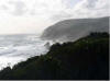
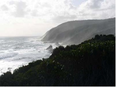
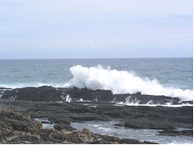
and mountain biking. We headed down to the campsite on the coast to find a
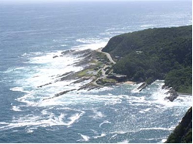
place to sleep. This has to be one of the most picturesque campgrounds
anywhere. Massive surf breaks onto a rocky coast just meters from the
campsite throwing up huge and spectacular spray. It’s the kind of thing
you can just sit and watch, mesmerized. We went for a short hike, then
cooked dinner and enjoyed the sounds of the surf. |
|
 |
|
Updated Information
|
Date |
Camp Site or Accommodations |
GPS |
Distance Today:
25km |
Meals
Chicken sandwich |
Weather |
|
Tsitsikama National Park, South Africa |
24 November, 2004 |
Park Campground |
34°01.418’S
x 23°53.408’E |
Odometer: 45238km |
Sunny, 92(F)
degrees |
|
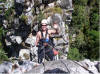
We awoke from a great night’s
sleep, enjoying the relaxing sounds of the pounding surf. Leaving our
table and chairs behind to secure our camp site, we drove to storms river
village. The tour company kitted us up with wetsuits and abseil harnesses,
then drove us a short distance to storms river gorge. We clipped in and
made a spectacular 110m rappel into the narrow canyon. At the bottom we
inflated our tubes and spent the next 2 hours floating and walking 1.6km
down the gorge. At the ‘take out’ we climbed back to a dirt road where
snacks and mountain bikes had been delivered. Four of us elected to do the
longer 22km ride that took us out to a viewing platform overlooking our
campground. Back at the office we ate our lunch at about 430pm, then
headed back to the camp. Full from our late lunch we skipped dinner and
spent the evening watching the waves crashing against the rock. |
|
|
|
Updated Information
|
Date |
Camp Site or Accommodations |
GPS |
Distance Today:
200km |
Meals
Sheep's Neck |
Weather |
|
Near George, South Africa |
25 November, 2004 |
Wouter's Farm |
Not Recorded |
Odometer:
45413km |
Partly Cloudy, 85(F) Degrees |
|
We went for a short hike this morning along
the first section of the otter trail, ending up at a waterfall. A brief
swim in the cold water at the base of the falls was very refreshing. It’s
easy to see why this hike is so popular. On the way back Jen spotted
several humpback whales and a few dolphins. After lunch we reluctantly
left Tsitsikama and headed for George, where we plan to stay with Wouter.
Graham Wilde from Johannesburg introduced us to Wouter, who is also
involved in the Tracks4Africa project. He and his wife Esther took us to
dinner at a local restaurant where we enjoyed sheep’s neck for our
thanksgiving dinner. We spent the
evening at their house talking about maps, travel, and Africa. |
|
|
|
Updated Information
|
Date |
Camp Site or Accommodations |
GPS |
Distance Today:
280km |
Meals
boerewors with pasta |
Weather |
|
De Hoop National Park, South
Africa |
26 November, 2004 |
Park campground |
Not Recorded |
Odometer:
45693km |
Sunny, 96F) Degrees |
|
After saying goodbye to Wouter and Esther
this morning we followed a route Wouter suggested that took us over a
beautiful mountain pass to the town of Outdshoorn where we met Johann, a
friend of Wouter’s who is also involved with T4A. He runs a Steer’s
restaurant and treated us to breakfast as we told him a little about our
trip. We continued east, stopping alongside the road for our standard
lunch of tuna, mayo, and sweetcorn sandwiches and Simba peri-peri flavored
crisps (potato chips). We stopped at a couple of vineyards and picked up
some port and a bottle of brandy. Shortly after a stop for groceries in
Swellendam we were stopped at a police roadblock. I was a little concerned
because my international drivers license expires today. They pulled over
every car on the road, stopped us, handed everyone little paper cups full
of coke, and waved us on, whishing us a good journey. Very strange. We
drove through some beautiful farmland on the way to De Hoop nature
reserve. In the park we saw bontebok and eland, two antelope we haven’t
seen before. We went to the beach to watch for whales
for a little while. Over dinner we lamented the fact that this might be
our last night of camping on the trip. |
|
|
|
Updated Information
|
Date |
Camp Site or Accommodations |
GPS |
Distance Today:
261km |
Meals
Roasted chicken |
Weather |
|
Hermanus, South
Africa |
27 November, 2004 |
Lynn and Dudley's house |
Not Recorded |
Odometer:
45954km |
Partly cloudy 84(F) Degrees |
|
We went for a hike along the
coastal trail this morning and spotted a few of the endangered oyster
catcher birds, as well as whales and dolphins. Leaving the park we headed
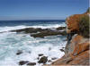
through more farmland to Cape Agulas, which marks the southernmost point
of the continent of Africa. In a strange geographical coincidence, this
point lies at precisely 20 degrees East Longitude. After some celebratory
photos we headed for Hermanus and Lynn and Dudley’s house (the couple whom
we helped when their car broke down near Mkuzi game reserve a few weeks
ago). They live in a beautiful home in the seaside resort town of Hermanus,
about a block from the sea. They put us up in their guest cottage. The
springboks were playing Scotland (rugby) and Dudley tried to explain the
game to us as South Africa trounced scotland. We went for a walk through
town while they made us dinner and we sat up talking until almost
midnight. They bought a grape farm in the Stellenbosch region in the 1970s
and recently turned it over to their two children who have recently
started making wine. They promised to set up an appointment to tour the
vineyards in a couple of days. |
Cape Aghulas, the southernmost point of Africa

Cape Aghulas, the southernmost point of Africa
|
|
Updated Information
|
Date |
Camp Site or Accommodations |
GPS |
Distance Today:
292km |
Meals
Grilled fish |
Weather |
|
Near Franshoek, South
Africa |
28 November, 2004 |
Campground |
Not Recorded |
Odometer:
46246km |
Sunny, 88(F) Degrees |
|
After breakfast with Lynn and
Dudley, we took the coastal route to Strand where we headed inland to the
wine region. Most of the vineyards had closed by the time we reached
Franshoek, so after a quick look around the very French town we located a
campground on the way to Stellenbosch. After having enjoyed a nice lunch
at a restaurant along the coast we decided to have some leftover pasta for
dinner. We have to be in Cape Town tomorrow so this will likely be our
last night in our tent. We enjoyed the sound of the nearby river as we
drifted off to sleep. |
|
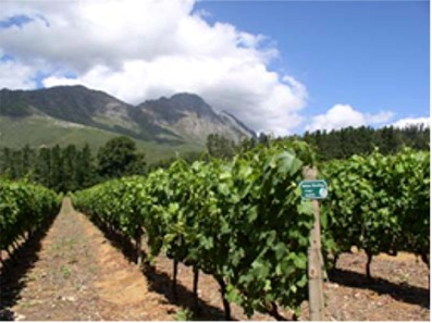
Vineyards in Stellenbosch |
|
Updated Information
|
Date |
Camp Site or Accommodations |
GPS |
Distance Today:
120km |
Meals
burgers at the bar |
Weather |
|
Cape Town, South
Africa |
29 November, 2004 |
The Backpack |
Not Recorded |
Odometer:
46366km |
Sunny, 92(F) Degrees |
|
We stopped first at the
Simonsvlei vineyard this morning. Perhaps it was because we had just
finished breakfast, but none of their wines tasted good to us. Next we
went to Praal to visit the large Nederburg estate. The wines here were
better and not too expensive, and we bought a few bottles. Next we drove
to Stellenbosch and stopped at the Marklew farm, run by Haide and Billy,
the daughter and son of Lynn and Dudley. They were very hospitable and
spent over an hour with us explaining their handcrafted wines. We took
advantage of their generous offer of wholesale pricing and bought 3 cases
of wine. Haide even phoned to Cape Town for us to book a room at a
backpackers. On her recommendation we stopped for an excellent lunch at
another winery and bought a couple more cases. Our wine tasting time
exhausted, we got on the road for the last leg of our trip to Cape Town.
After the usual big city navigation and traffic hassles, we managed to
locate the backpackers in the city center. We were tired from a hard day
tasting wines, but we have to be at the dock to send rafiki off tomorrow
morning at 10am, so we spent the evening changing ourselves from
overlanders to backpackers. We cleaned out the fridge and packed it with
wine, and pulled out our clothes and backpacks. After a quick dinner we
went to bed. |
|
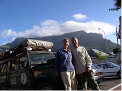
Cape Town |
|
November 30 ---> |